We turn ideas
into web applications
Online applications, efficiency, maps
We identify your idea and take care of its implementation in the form of a tailored, efficient, and stable web application. Our primary goal is to move your business forward through mutual cooperation.
Cooperation
How we work
We have wide experience both with independent subcontracts and with integration into a larger development team. We are also familiar with various environments, from startups to medium-sized companies to scientific research projects.
We have two basic forms of cooperation. The first option is custom development. You describe your vision to us, then we prepare an offer that includes the specification, price and delivery date, and after approval of the offer, implementation follows. The second option is the agile development method, where we set the initial requirements in less detail and continuously refine them. In this case, we deliver outputs very often, for example every week, and we are paid according to the hourly rate.
The principles that enable us to be consistently high in efficiency:
- We value the resources of our partners, so we often ask for feedback and improve cooperation based on it.
- We like to bring real value to customers, so we try to prevent errors and routine activities by automating whatever makes sense. Most often tests, deployment and bureaucracy.
- We realize that you understand customer needs better than we do, that’s why we often ask what the functionality is used for and what value it is intended to bring.
- We care about quality and replaceability, which is why code review is a regular part of our work, either among ourselves or with your team.
- We save time, so apart from essential meetings we work remotely.
What we can do
We consider ourselves full-stack developers. A programming language is just a tool for us, the meaning is the value for the customer. At the same time, we learn new technologies very quickly and gladly.
We currently use the following tools and processes:
- Python, Flask, Django, Celery, REST APIs
- JavaScript, Node.js, React.js, Redux
- PostgreSQL, Redis
- Docker, Docker Compose, Git, DigitalOcean, Nginx
- test automation, code review, continuous integration
- standard Python frameworks for working with deep neural networks
We have many years of experience in creating and maintaining large systems in the finance and energy fields, as well as web content management systems. Thanks to this, we are able to quickly jump into ongoing projects while doing simple things simply.
Because we often operate in the field of geographic information systems, we have perfect control of GDAL, PostGIS, OpenLayers, GeoServer, and other tools.
Why are we two
We know that we complement each other perfectly, we can substitute each other, we bring different perspectives, and together we can bring better results than separately.
References


Year by year
2024
- Under the ExpertaLabs brand, we automated dozens of test cases for Flowmon Network a.s.. Both pure back-end test cases in Python and Pytest, and GUI test cases in Cypress.
- For Mapotic s.r.o. we created the foundations of a unified platform for quick and simple creation of individual client applications. The platform allows the creation of a new application for live motion tracking just by configuration without the involvement of any developer.
- We released first version of our own PWA Pomootskey helping decrypting during puzzle hunts.
2023
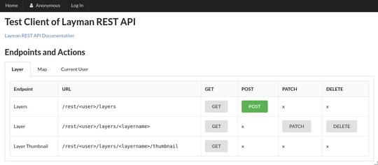
- We improved the Layman service:
- update the integrated GeoServer to v2.21
- addition of WMS legend for layers with QML style
- Under the banner of the company Altimapo, we added datasets from the Census of Population, Houses and Apartments 2023 to the BrnoUrbanGrid and DataMapo portals, as well as 5 data sets related to traffic accidents.
- We collaborated with the Department of Geography and the RECETOX Institute on the project Stress of Citizens and Entropy in Urban Setting (STRECITY).
- We created an internal version of the mapserver.czechglobe.cz portal for CzechGlobe.
2022
- We improved the Layman service:
- support for multiple input coordinate systems
- filtering of publications using a bounding box in different coordinate systems
- user choice of raster pyramid normalization method
- creating publications whose name starts with a number
- publication of time series data
- improvements in displaying grayscale raster data
- At the Institute of Geonics of the Czech Academy of Sciences, we trained the publishing of maps on the website for intermediate learners.
- Together with the Department of Geography, we successfully completed the project Modeling the daily dynamics of the number of people present in an urban space (MODUS).
- We started collaborating with the Department of Geography and the RECETOX Institute on the Stress of Citizens and Entropy in Urban Setting project (STRECITY).
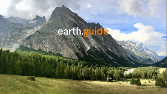
- With the earth.guide team, we created a module for automatic tagging of photos. The photos are labeled as “forest”, “church”, “waterfall” and the like. Subsequently, we improved their Android application with the possibility to share articles, including their location on the map, in addition to photos.
- Under the banner of Altimapo, we improved the method of loading data for individual grid cells in BrnoUrbanGrid.
- Under the banner of Altimapo, we created the DataMapo portal displaying grid statistics for the entire Czech Republic.
- For the FollowMe service, we created an administrator web application for mass import of starting list.
2021
- We improved the Layman service:
- expansion of the list of supported output coordinate systems
- publication of vector data with QML styles
- publication of raster data
- new GET Layers and GET Maps endpoints that return all users' publications, including filtering and sorting results
- automatic update of bounding box and preview image after data change, including WFS-T queries
- support for GeoTIFF and JPEG2000 raster formats
- updating the versions of GDAL, PostgreSQL, and PostGIS support tools
- publication of layers in ZIP compression format
- We launched the Charcoal piles portal for RILOG.
- We converted the mapserver.czechglobe.cz portal to Python v3 and Node.js v16, including updating other libraries.
- We started working together with the Department of Geography on the project Modeling the daily dynamics of the number of people present in an urban space (MODUS).
- At the Institute of Geonics of the Czech Academy of Sciences, we trained in publishing maps on the website for beginners.
- The EnjoyChallenge.tech brand was created.
2020
- We improved the Layman service:
- automatic generation of metadata records published via the Catalog Service interface
- authenticated access to WMS and WFS interfaces using OAuth2
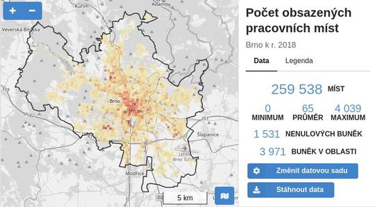
- We participated in the expansion of BrnoUrbanGrid from the territory of the Brno metropolitan area to the entire South Moravian region, including an advanced generalization of grid data.
- We started working together.